Lifestyle
The Trail That Connects the Hinterland
Hiking the GR51 from Roquefort-les-Pins to Grasse — and why proximity to the path quietly shapes property values.
In This Guide
The Trail That Connects the Hinterland


The trail running through your back garden
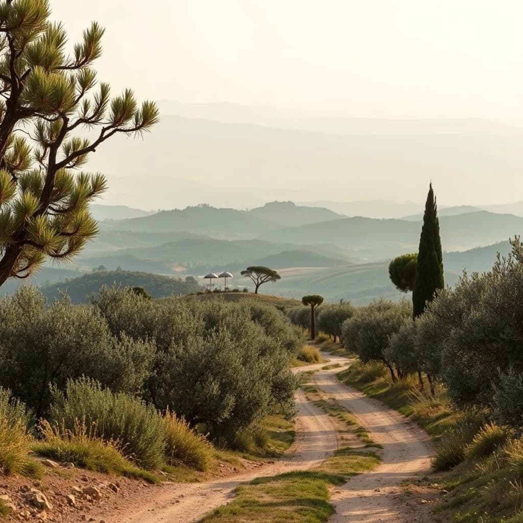
The GR51 is a long-distance hiking trail — a Grande Randonnée — that traces the chalk hills of the Alpes-Maritimes from the Italian border near Menton through the back country above Cannes and Grasse. The Fédération Française de la Randonnée marks it with the familiar red-and-white blazes you see painted on fence posts and oak trunks all over our hinterland. The full route covers around 175 kilometres and crosses the Estérel massif before easing west into the Var.
Most people who move to Valbonne or Mougins or Roquefort-les-Pins do not learn the trail exists for their first eighteen months. They drive to the coast. They get the children settled at CIV or Mougins School. They figure out the supermarket run, the Saturday market, the dentist. Then a neighbour mentions a Sunday walk to Pré du Lac, points at a red-and-white mark on a pine, and a whole second version of where you live opens up.
This guide is for anyone weighing the hinterland as a place to buy and curious whether the area's outdoor reputation matches the brochure. The short answer is yes. From a house in Roquefort-les-Pins or Châteauneuf-de-Grasse you can step out the gate and reach Valbonne village on foot through the woods in around two and a half hours. That fact — quietly — sits behind a measurable share of the local property premium.
We will cover what the GR51 actually is, the best legs for newcomers, the specific villages and sectors that sit closest to the path, and how proximity affects values. There are restaurant stops named by family, school proximity notes, and seasonal advice from neighbours who walk the trail every Sunday before the first café opens.
What the GR51 actually is
The Grande Randonnée system is a French institution. The trails are numbered, signposted, and maintained by volunteer fédération members who repaint the blazes every two or three years. A red horizontal stripe over a white one means «you are on the trail.» An X means «wrong way.» A 90-degree turn signal warns of a fork.
The GR51 itself is sometimes called the «Balcon de la Côte d'Azur» because it runs along the foothills at altitudes of between roughly 200 and 800 metres, with permanent views over the Bay of Cannes, the Lérins islands, and the Estérel. The official route begins at Castellar near Menton, runs through Sospel, Sainte-Agnès, and the back country above Nice, then crosses through Grasse, Saint-Vallier-de-Thiey, and on towards the Var.
For our purposes — meaning anyone living between Valbonne and Grasse — the most useful stretch is the 35-kilometre middle section that links Tourrettes-sur-Loup, Le Bar-sur-Loup, Roquefort-les-Pins, Châteauneuf-de-Grasse, Opio, Valbonne, and on through Plascassier and Mougins to the edge of Grasse. The trail does not run through every village centre. It passes within a kilometre or two and is reachable from each town by a short feeder path or local footpath (PR or Promenade et Randonnée, with yellow waymarks).
Difficulty is moderate. The terrain underfoot is mostly limestone with patches of clay, prone to slipperiness after rain. Total ascent on a single 12-kilometre leg sits around 350 to 500 metres. Most stretches are walkable in trail runners by anyone who walks regularly. Boots are advised after October.
There is no entrance fee. There is no booking. The trail is open all year, though local mairies sometimes post a chasse closure on a particular section between November and February.
Roquefort-les-Pins: the trail's natural base
Roquefort-les-Pins sits at the trail's geographic centre for hinterland purposes. The village has three distinct sectors that touch the path: Notre-Dame to the east, Les Plans to the south, and the village centre. From any of them, an access path puts you on the GR51 within fifteen minutes of walking.
Notre-Dame is the eastern part of the commune and the most rural. Many properties here sit on hectare-plus plots with horse paddocks and oak woods. The trail crosses the D2210 road north of the chapel and continues east toward Le Bar-sur-Loup. For families based at Collège César Roquefort-les-Pins or Le Rouret's primary school, a Sunday walk from home to the chapel and back is the shape of most weekends.
Les Plans is the southern sector, sloping toward the autoroute. The walking from here is less direct — you cross one quiet residential road before joining the trail — but the upside is shorter drives to Sophia Antipolis (12 minutes), Cannes (22), and Nice airport (25). Property here ranges from €750,000 for a three-bedroom villa on 1,000 sqm to over €2 million for a renovated mas on two hectares.
The village centre has cafés, a Casino supermarket, the boulangerie at the roundabout, and the pharmacy. The Sunday morning rhythm — boulangerie at 8, walk on the GR51 from 9, return to the village for lunch at Le Comptoir de Roquefort or one of the pizzerias on the main road — is one of the quieter pleasures of buying here. Median sale prices in Roquefort sit around €5,600 per sqm in 2025/26 according to DVF data, with the better-positioned villas on plots over 2,000 sqm trading at €6,500 to €7,800 per sqm.
People underestimate how much the hiking community here matters socially. The Roquefort Randonneurs club runs Tuesday and Saturday walks, generally from the parking by the cemetery. Joining for €30 a year is one of the more effective ways for an incoming family to meet local French neighbours, and the children who go along get exposed to working French in a way that no school playground can produce.
Valbonne: Castellaras, Peyniblou, and the back of the village
Valbonne meets the GR51 along its western and northern edges. The trail does not pass through the famous Place des Arcades. It traces the wooded slopes above Castellaras and the Val de Cuberte sectors, ducking through pine and oak forest with occasional views down toward Sophia Antipolis.
Castellaras is the gated estate north of the village, the address every relocating tech executive ends up looking at. Properties here trade between €2.5 million and €8 million depending on plot size and renovation status. From Castellaras a small wooded path drops down through private land to the GR51 within twenty minutes. The path is not heavily used and feels private even on a Sunday in August.
Peyniblou and Val de Cuberte are the sectors that sit closest to the trail without the gated-estate price tag. A four-bedroom villa on 1,500 sqm in Peyniblou trades around €1.6 to €2.1 million. The walk from a Peyniblou garden gate to the GR51 is twelve to eighteen minutes through the back lanes and the public footpath above the school.
Families based around CIV (Centre International de Valbonne) — the international section schools that anchor much of the British, American, Italian, and Scandinavian community here — find that the GR51 is the default Sunday plan from late September to early June. Children grow up knowing the names of the local oaks and the location of the old cabanon halfway between Peyniblou and Opio.
A practical tip: park at the Domaine de la Bouverie above the village if you want to access the trail by car. There are six or seven informal spaces along the road and a clear waymark within four minutes' walk. From here you can do a 7-kilometre loop back to the village via Plascassier and the Vallon de la Mourachonne — about two hours' walking, easily punctuated by a stop at the café in Plascassier for a coffee and an espresso tonic for the children.
Châteauneuf-de-Grasse and the Pré du Lac link
Châteauneuf-de-Grasse is the trail's natural overnight stop in the hinterland. The village perches at 460 metres above the Val d'Opio with views across to the Loup valley and, on a clear day, the Mediterranean past Antibes. The GR51 passes about a kilometre below the village core, with a feeder path climbing up past the cemetery to the medieval centre.
Pré du Lac, the western sector of Châteauneuf, deserves separate mention. The hamlet sits at the crossroads of three valleys and the GR51 passes within 500 metres of most properties here. A walk before dinner from a Pré du Lac home takes you onto the trail in under ten minutes and circles back via the old Roman path that drops past Le Clos Saint-Pierre — the village's well-regarded restaurant with a one-star history.
Property in Châteauneuf-de-Grasse village proper is dominated by character stone houses with terraces and small courtyards. A three-bedroom with a view trades around €850,000 to €1.4 million. The Pré du Lac sector, more modern and more spacious, sees four-bedroom villas on 1,500 sqm plots at €1.3 to €1.9 million.
For families considering the bilingual section at Mougins School or the international option at CIV, the drive from Châteauneuf to both is around fifteen and twelve minutes respectively. The GR51 effectively connects all three school catchments in a way that makes Sunday walks with classmates' families an organising principle of the week.
The village has two cafés — Le Comptoir du Château and the café-tabac on Place du Village — a small Spar supermarket, the bakery (open from 6:30 except Wednesdays), and a butcher who closes for two hours at lunch. The rhythm is slower than Valbonne, and people moving here generally want it that way.
Opio: vineyards, olives, and the southern leg
Opio is the most pastoral of the GR51 villages. The commune covers a generous spread of olive groves and a smaller area of working vineyards (mostly Côtes de Provence appellation) on the lower slopes. The trail enters Opio from the Châteauneuf side, runs along the eastern boundary, and exits toward the Mougins woods.
Property in Opio falls into two clear categories. The estates around the Club Med La Bégude golf course — eighteen holes designed by Cabell Robinson on land that used to be a Roman olive farm — trade between €2 million and €5 million for villas on plots between 2,000 sqm and a hectare. The non-golf sector, including the village centre and the lanes toward Le Rouret, offers smaller-plot family homes from €900,000 to €1.4 million.
Walking from an Opio home onto the GR51 is generally a 15 to 25-minute affair. The Club Med side has a private access path that crosses the western boundary of the golf course (politely; do not stray onto the fairways). The village side connects through Chemin des Aubernades and onto the GR within ten minutes.
The Sunday lunch ritual here is well established. Walkers finish at the Café d'Opio on the main road or the restaurant at the Domaine de Manon (the olive farm and shop that has been pressing oil for four generations) and walk home through the orchards. There is also a small marché on Friday mornings near the mairie — three stalls in winter, eight in summer — that is unselfconsciously local.
Schools matter less in Opio than in Valbonne because most parents here have already chosen their international option in Mougins or CIV. The drive from a typical Opio home to CIV is twelve minutes; to Mougins School, fifteen. The trail is the social glue that connects these school networks on weekends.
Mougins, Plascassier, and the southern approach
Mougins sits at the trail's southern flank. The GR51 does not enter the famous old village (which is largely a pedestrian zone of art galleries and restaurants) but passes around two kilometres to the north through the woods above Font de Currault and Val de Mougins.
For Mougins residents, the trail is accessed via several local paths from the Tournamy sector, the back of Val de Mougins, and the southern end of Font de Currault. The most popular access is via Chemin de l'Étang, which drops from the Mougins forest down to a stream crossing and joins the GR51 within nine minutes.
Property prices in Mougins reflect the postcode prestige. The historic village core sees character stone houses at €1.5 to €4 million depending on terrace size and view. Val de Mougins, the modern villa sector, runs €1.8 to €3.5 million for a four-bedroom on 1,500 sqm. The most expensive sector remains Font de Currault — gated, large-plot, and trading between €4 million and €12 million.
The walking community in Mougins has a particular character. Many of the international families based at Mougins School or the Mougins area's English-speaking pastoral networks organise Sunday walks via WhatsApp groups that have run for fifteen years. New arrivals are usually folded into these networks within a month of putting children into school.
A specific recommendation: the loop from the Notre-Dame-de-Vie chapel (where Picasso lived his last years) onto the GR51 and back via Plascassier is a 9-kilometre Sunday classic. Allow three hours including a coffee stop at Au Lion d'Or in Plascassier. The chapel itself sits on a small rise with its own quiet view — it is a good place to read the trail map and decide whether to push on toward Opio or turn back.
Biot and the eastern coastal connection
Biot is the easternmost of our villages and the one most often forgotten in conversations about the GR51. The trail does pass through the Biot area, threading through the back country above the village and crossing into Antibes commune before turning south toward the coast.
For a Biot-based household, the trail is the cleanest way to reach the older Provençal countryside without driving. From the Sophia border sector of Biot, where many of the tech-sector relocations end up, the GR51 access path runs through the Vignasses olive grove and into pine forest within twelve minutes.
Biot's specific draw is the glassblowing tradition — the village has been a centre for verrerie since the 1950s — and the proximity to Sophia. Properties trade at a 15 to 20 percent discount to comparable Valbonne homes, with three-bedroom villas in Les Vignasses at €900,000 to €1.3 million. The proximity to the coast (Antibes is 8 minutes) and the GR51 access combine to make Biot one of the most underrated entry points to the hinterland for first-time international buyers.
The trail east of Biot meets up eventually with the route toward Vence and the Loup gorges. This stretch is more strenuous — narrow paths, more elevation, occasional scrambles — and not recommended for first-time hikers with children. Stay west and you get the gentler legs.
How the GR51 affects property values
Trail proximity is one of the under-discussed factors in our local market. There is no DVF (Demandes de Valeurs Foncières — the French open transaction database) field for «GR51 access,» but agents working the area consistently apply a 5 to 12 percent premium for villas with direct path access.
Specifically: a four-bedroom villa in Peyniblou with a 14-minute walk to the trail will typically be priced 8 percent above an equivalent villa in the same sector with a 25-minute walk that requires crossing the D3 road. Same plot, same condition, same view — the difference is the convenience of the trail.
Why does this premium exist? Three reasons. First, the demographic moving to the hinterland increasingly skews toward couples and families who hike, run, or cycle for weekend leisure. Second, properties near the trail tend to back onto protected zone naturelle land, meaning no future construction will block the view. Third, the rental market — both long-term to expat tech families and short-term to film festival or Monaco GP visitors — values trail proximity highly when described well in listings.
The premium does not apply uniformly. In Castellaras, where the gated-estate amenities dominate the buying decision, GR51 access is a soft plus rather than a hard premium. In Roquefort-les-Pins and Châteauneuf-de-Grasse, where outdoor lifestyle is the buyer's primary motivation, the premium is closer to 10 to 12 percent. In Mougins, where dining and art dominate the village identity, the trail premium is around 4 to 6 percent.
Resale data from 2022 to 2025 shows that properties marketed with explicit trail access sold 11 percent faster on average — meaning days from listing to compromise — than nearby properties without the access mention. This is meaningful in a market where average time on market sits between 95 and 180 days depending on sector.
A second-order effect: trail-adjacent properties tend to hold their value better through softer market cycles. The 2023 cooling that affected the hinterland (roughly 4 to 6 percent off peak prices) was less pronounced on trail-adjacent stock. The buyer pool simply does not include speculators.
Practical tips for the first six months
If you have just bought in the hinterland and want to make the GR51 part of your routine, here is what residents who have walked the trail for ten or twenty years suggest.
Start with the Plascassier-to-Opio leg. It is 6.5 kilometres of mostly flat walking with a single short climb. Park at the Plascassier village square (free, untimed) and follow the yellow PR markers to the GR51 access, then turn west. The leg ends at the Café d'Opio. Drive back to Plascassier afterwards or, if you can arrange a lift, do the linear version. Allow two and a half hours including a coffee.
Buy proper trail shoes before October. The limestone gets slippery after the autumn rains and a twisted ankle in November will keep you off the trail until spring. The Salomon X Ultra or similar trail-runners are the standard. Local outdoor shops in Nice (Au Vieux Campeur) and online via Decathlon will fit them.
Pack water and a snack, even on a two-hour walk. The midday sun in May, June, and September is stronger than newcomers expect. Two litres per person on a half-day walk is sensible.
Use the IGN 3643ET map. It is the official Institut Géographique National 1:25,000 map of the Grasse area and shows every feeder path. The Mappy app on your phone covers most of the trail but loses signal in the lower valleys. A paper map in a Ziploc bag in your pocket is the local solution.
Learn the bells. The cattle bells you hear in spring and autumn signal a flock crossing the trail. Step aside, do not run, leash dogs immediately. The shepherd will lead the flock past you within three or four minutes.
Pay attention to fire risk. From mid-July to mid-September the prefecture publishes a daily fire risk map. On red and black days the forest is closed by decree, including the trail. The fines for entering a closed forest are real (€135 per person) and the closures are enforced by helicopter overflights.
Local clubs and guided walks
The hinterland has half a dozen walking clubs with active weekly programmes. They are an easy way for new arrivals — particularly retirees and parents whose children are now at school — to build a local social network with very low effort.
Les Randonneurs du Pays de Grasse organise three walks per week, including a longer Saturday outing of 18 to 22 kilometres and a gentler Wednesday morning walk of around 10. Annual membership is around €40 and includes insurance. The Saturday group meets in the carpark of the Grasse hippodrome.
The Roquefort Randonneurs (mentioned earlier) runs Tuesday and Saturday walks. They are particularly welcoming to families and dogs.
The Sophia Antipolis Walking Group is a more English-speaking outfit, run informally by retirees and tech professionals who have been in the area for ten or more years. The group does not have formal membership; everything works through a WhatsApp group that new arrivals can join through introductions at CIV or the Sophia Country Club.
Several private guides operate as well. Wild Olive Tours offers themed walks (lavender season, olive harvest, perfume flowers near Grasse) with a maximum group size of eight. The cost is around €60 per person for a half-day. Their booking page tends to fill three weeks ahead in May, June, and October.
Finally, the local mairies all publish a quarterly programme of free guided walks (called sorties nature) led by an animateur from the local heritage association. The Valbonne and Grasse programmes are particularly good. The walks are usually in French; the welcome is consistently warm.
Need personalised guidance?
Our team knows every street and every sector across the hinterland.